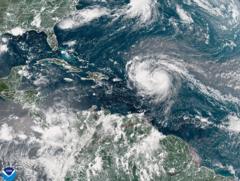
Hurricane Erin has escalated into a fierce Category 5 hurricane, with maximum sustained winds reaching an astonishing 160 mph (260 km/h). The National Hurricane Center’s Mike Brennan highlighted that the storm underwent rapid intensification, growing from tropical storm status just a day prior. Erin is forecasted to traverse north of the Leeward Islands, Virgin Islands, and Puerto Rico this weekend, potentially dropping up to 6 inches (15 cm) of rain, increasing the risk of both flash flooding and mudslides.
As the first hurricane of the 2025 Atlantic season, Erin's rapid development signifies its dangerous nature, having surged from 100 mph early Saturday to 160 mph. Moving forward, it is expected to drift northward, passing east of the Bahamas and heading towards the Outer Banks of North Carolina. Potentially life-threatening surf and rip currents are anticipated along nearly the entire East Coast, with Florida and mid-Atlantic states facing the most severe conditions.
Additionally, Bermuda may experience treacherous surf and heavy rainfall due to the storm. To ensure safety amid gale force winds, the US Coast Guard has implemented restrictions on vessels in ports at St. Thomas, St. John in the US Virgin Islands, and various municipalities in Puerto Rico, including San Juan. The National Oceanic and Atmospheric Administration (NOAA) has projected a busier-than-normal Atlantic hurricane season this year, indicating an increased likelihood for powerful storms fueled by global warming.


